What WaterView can do for your district.

WaterView™ is a water efficiency and data management software solution custom-designed to help water professionals meet the water conservation framework requirements under SB606 & AB1668 and comply with the new efficiency standards.

Compliance

Meet the efficiency and allocation requirements established under SB606 and AB1668 with ease.

Efficiency

Use detailed irrigation and demographic data to help move customers toward long-term, efficient water use behaviors.

Adaptation

Adapt to state mandates and changes while maintaining customer satisfaction and supporting the financial resilience of your district.

Management

WaterView mirrors current legislative requirements and reporting so you can focus on your staff and customers, not requirement changes.

What is your compliance plan?

The requirement to start measuring water for the 2024 Urban Water Use Objective began:

07 / 01 / 22

00
Days
00
Hrs
00
Min
00
Sec

Pending conservation requirements and reporting are looming. How will your district adapt? WaterView helps districts avoid penalty fees and stay compliant by providing data that fuels holistic water-efficiency campaigns with three goals: water efficiency, customer satisfaction, and minimal to no revenue reduction.

98% of the states urban water suppliers don’t have the data they need to comply. The clock is ticking and you’re likely behind

The state has given water agencies time to get into allocation because it takes a significant amount of time and resources to execute the actions necessary. Even filing, which every water agency is required to do requires significant actions being taken in order to comply. This requires accurate data that 98% of water suppliers don’t have and knowledge of the legislation. If you don’t have a solid plan in place, it’s time to take action.

Discover what data I’m missing & build my plan
Budget & staff

+22%

Growth

How WaterView helps districts avoid the pitfalls of water-usage cuts.

25% water cuts across water districts in 2014 led to upset customers and a dependence on reserves. A lack of choice forced led districts to make decisions that had negative repercussions. WaterView gives districts the data they need to make better decisions with the multi-faceted whole picture in mind. Efficancy doesn't have to mean hardship for your your district. Learn more below.

No GIS training needed
Integrates with existing GIS systems

Ensure DIM/MUM data accuracy for compliance

Avoid costly manual field measurements through our proven remote approach

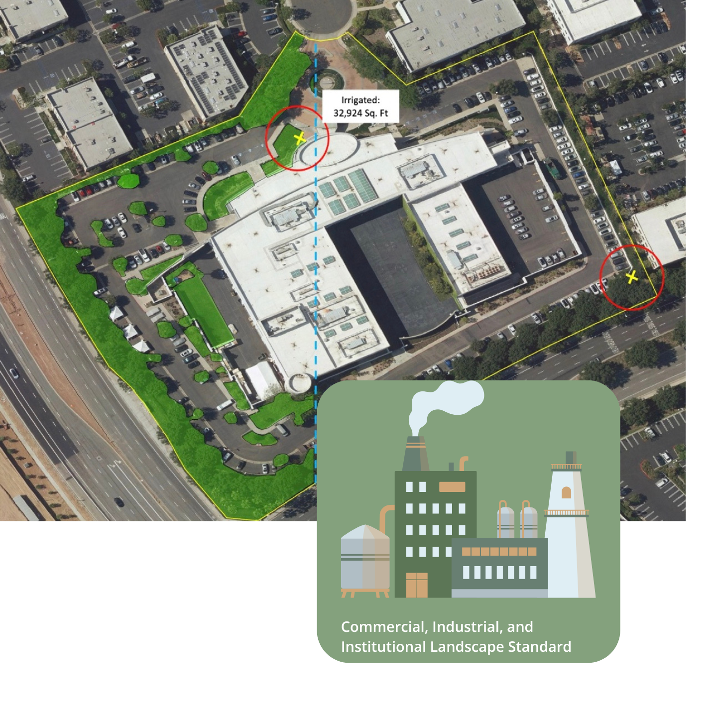
Accurately define your DIM boundaries and qualified MUMs remotely in 95% of cases—eliminating the need for site visits. Efficiently clustering DIMs saves time, cuts costs, and further reduces on-site assessments, making compliance seamless and cost-effective.

SALES
+4.4%

$620K

Compared to ($300K last year)

Award Winning Aerial Streaming.

Our award winning Aerial Streaming Solution provides a web-based imagery stream (along with other geospatial data) to our subscribers for your aerial photography. Our web-based clients can stream the imagery right into their own geospatial applications like AutoCAD, ESRI, and many more. The geospatial data is distributed using RESTful services like WMS, WMTS, WFS and WCS. Due to that users are assured that access to the data is Open Geospatial Consortium (OGC) standards-based, meeting and exceeding world-class data delivery speeds.

National 1 Foot Pixel Coverage.

Eagle’s 1-foot pixel resolution ortho library extends across the United States and is updated regularly. All imagery is captured using cutting edge digital aerial mapping cameras. This data undergoes an extensive ortho-rectification process and quality control making it the most horizontally accurate one-foot pixel resolution aerial ortho-imagery available today. Tapping into our Off-The-Shelf (OTS) imagery model we can now offer national coverage at a substantially lower cost and faster turnaround times than traditional custom capture methods. Imagery is available from 1 square 1 square mile/km to whole populated areas.

Water Usage
Total REDUCTION
Campaign results
16%
Total
ABOUT US

Eagle Aerial Partnerships

As a team with NV5, Eagle has performed numerous irrigated vegetation analytic projects for water agencies, including the statewide residential irrigated vegetation project conducted on behalf of DWR. In addition, Eagle has developed several web-based software solutions for water agencies. Including the “Verification Portal” developed for DWR, allowing individual water agencies to confirm the accuracy of the statewide irrigation dataset.

LAM project

Eagle Aerial Solutions together and its partner, NV5 (formerly Quantum Spatial), are the companies that recently conducted the statewide Landscape Area Measurement (LAM) project for the California Department of Water Resources.

LAM delivered

The LAM dataset produced by Eagle and NV5 on behalf of DWR has been provided to each 400+ California urban water districts, free of charge.

LAM team

The Eagle/NV5 team includes multiple PhD-level remote sensing analysts whose skill has been required to develop this methodology over many years, in conjunction with the DWR team.

How Eagle Aerial got it's wings.

1987
The Eagle Equipment Check List entailed:

A camera, that’s it! Aircraft and photo post production was all outsourced. Within a year, a helicopter and custom color photo dark room were added.

1996
Eagle Went Digital!

All imagery was still film-based but, scanned and converted into digital files for electronic delivery or printed on a digital printer. Although digital aerial cameras were available in the early 2000’s, they did not make economic (or quality) sense for most applications until 2009. Prior to 2009, the large 9″x 9″ format film camera digitally scanned film had higher quality than digital aerial cameras.

1999
High Resolution

Eagle Aerial Solutions was the first aerial imaging company in the country to introduce high resolution “off-the-shelf” wide area coverage digital aerial imagery . For the first time, this provided customers with immediate, unlimited access to extremely accurate, high resolution imagery.

2011
Precision 3

Eagle Aerial Solutions’ new “Precision 3” off-the-shelf ortho imagery product surpassed the competition as the first annually updated, full Orange County coverage 3 inch pixel resolution imagery with engineering grade horizontal accuracy, available at a fraction of the cost of comparable custom-flown imagery.

2013
A leading provider

Eagle Aerial continues as California’s leading provider of current off-the-shelf aerial imagery and begins to release current imagery in major markets outside the state, including Phoenix, Las Vegas, Salt Lake City, Dallas/Ft. Worth, Houston, Chicago, Austin, and the District of Columbia.

2015
One foot pixel

Eagle expands its offerings by making available nationwide off-the-shelf imagery at 6 inch and one foot pixel resolution.

2017
Award Winners

Eagle Aerial Solutions received the 10th Annual MAPPS Geospatial Products and Services Excellence Award (Grand Award for Project of the Year) for its web-based imagery streaming service “Earth on Demand”. “Earth on Demand” delivers imagery and other geospatial data (raster and vector) in near-real-time to web clients and desktop geospatial applications.

2017
Near Infra Red

Eagle and its partners are currently using remote sensing technology to assist the State of California (DWR) in its statewide water conservation efforts. We are using NIR (Near Infra-Red) imagery and proprietary technology implemented by our PhD level analysts to efficiently provide detailed data to support equitable and cost-effective conservation approaches.